By Fraser & Cathy Goff
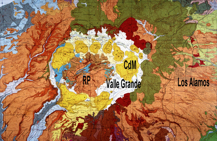
In Northern New Mexico, we are fortunate to be situated very close to the Valles Caldera: one of the most famous volcanoes in the world (Fig. 1). A caldera is a large volcanic depression, more or less circular, the diameter of which is many times greater than subsequent post-caldera eruption vents.
Based on a seminal publication by scientists of the U.S. Geological Survey (Smith and Bailey, 1968), the Valles is known as the world’s “type” resurgent caldera. A resurgent caldera has a structurally uplifted central dome (Redondo Peak, Fig. 1) and a ring of post-caldera lava domes, like Cerro del Medio. A “type” example means that this volcano was the place where this kind of volcanism was first described.
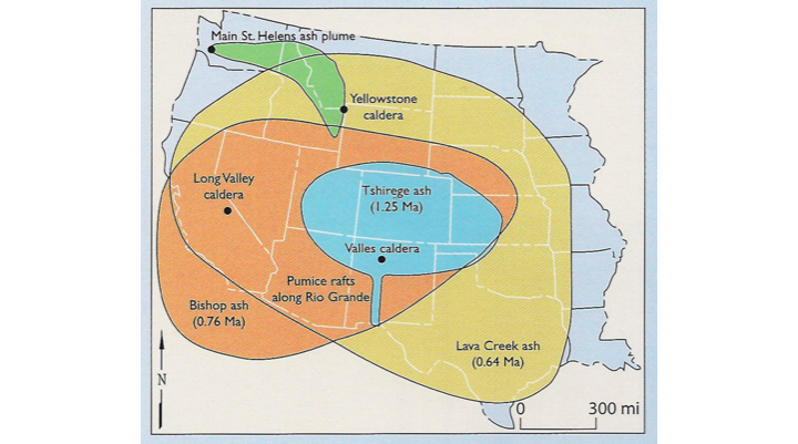
There are three large, relatively young calderas in the United States: Yellowstone, WY (0.64 million years old), Long Valley, CA (0.76 million years old), and the Valles (1.25 million years old). Although the Valles is the oldest and the smallest of the three, the eruptions that produced it were anything but small. About 400 cubic kilometers (95 cubic miles) of hot pyroclastic flows erupted in a period of a few months or less and formed a near-circular apron of consolidated ash, the Tshirege Member of the Bandelier Tuff. A pyroclastic flow is a fast-moving cloud of volcanic gases, ash, and chunks of pumice and lava. Well-known examples include the eruption of Vesuvius that buried Pompeii in pumice fall deposits, and the Mount St. Helens eruption in 1980. The pyroclastic flows from the eruption of Vesuvius wiped out Herculaneum on the west flank of the volcano. The flows erupting from the Valles reached temperatures of about 400 °C (752 °F)! The pyroclastic flows were dispersed at velocities approaching about 200 km/hr (124 miles/hr), filling valleys in the pre-existing terrain and forming thick deposits of tuff that we now call the Pajarito and Jemez Plateaus, east and west of the Valles, respectively.
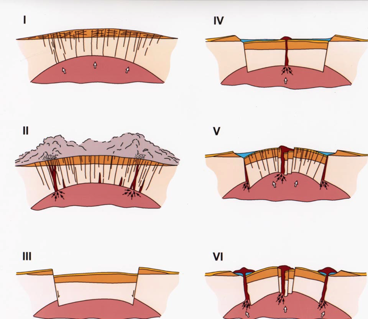
From their work at the Valles, Smith and Bailey (1968) published the “standard model” of large caldera formation, a model that is used to compare and contrast calderas to this day (Fig. 2). Magmas of the Bandelier type erupt at 700 to 900°C (1292 to 1652 °F) and contain substantial amounts of dissolved water, up to 6 percent of the magma by weight. Hot, water-rich magma is less dense than surrounding rocks, so the magma slowly rises toward the Earth’s surface.
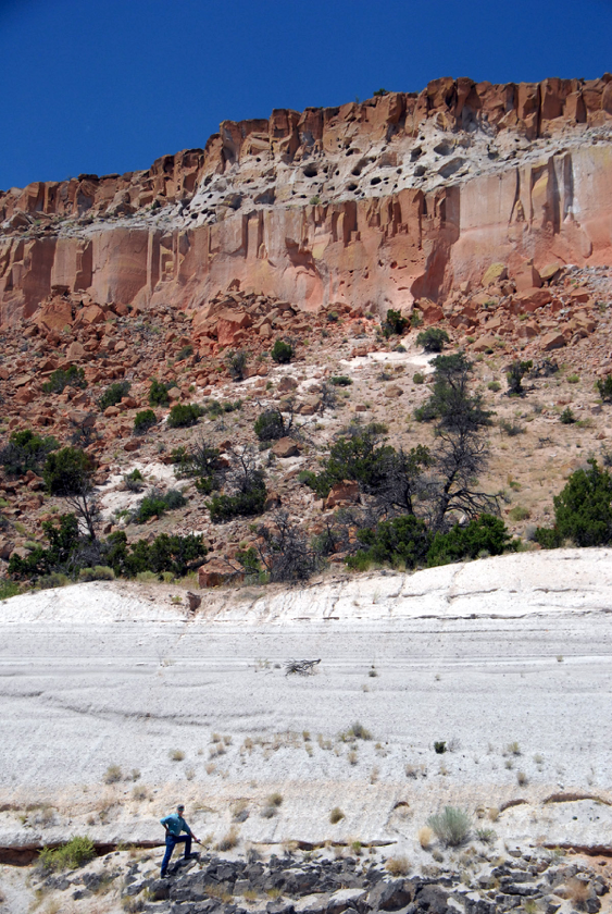
When the magma rises close to the surface, the pressure of the overlying cold rock can no longer prevent the dissolved water from forming water vapor (steam) in the magma, just like when you slowly open a shaken soda bottle. Then the magma explodes violently, producing superheated clouds of steam, gas, volcanic ash, and mineral fragments from crystals in magma, pumice, and fragments of the surrounding rock. Together, they form pyroclastic flows (Fig. 3). Ash fills the sky, and pumice (gas-inflated magma fragments that quench in the cold atmosphere) rains down. When the flows come to rest, they solidify, forming “welded tuff” (Fig. 4).
For a good visual of pyroclastic flows, check out this photo of a truck fleeing the famous 1991 eruption of Mount Pinatubo, Philippines.
The Valles Caldera was preceded by the comparably sized Toledo caldera, which erupted 1.62 million years ago and produced the Otowi Member of Bandelier Tuff. The Otowi is the darker orange unit on the geologic map of Fig. 1, but the paired tuff sequence is exposed in deep canyons all around the Valles (Fig. 4). Because the two calderas formed nearly on top of each other, formation of the Valles nearly obliterated geologic evidence for the Toledo caldera.
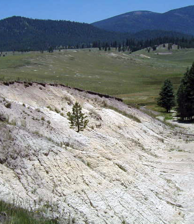
Because calderas form large topographic depressions, they often contain lakes that capture rain and snow (Fig. 2). Crater Lake, OR is such a lake in a small caldera, but Lake Yellowstone and Lake Crowley are large intracaldera lakes in the Yellowstone and Long Valley calderas. We know that Valles contained several lakes during its history because many fine-grained lacustrine (lake) deposits are exposed in and around the large valleys (Fig. 5). A well core obtained from Valle Grande in 2004 intersected 75 m of lake deposits that accumulated 300 to 520 thousand years ago. The Valle Grande lake deposits are hidden by only a few meters of younger valley-fill sediments.
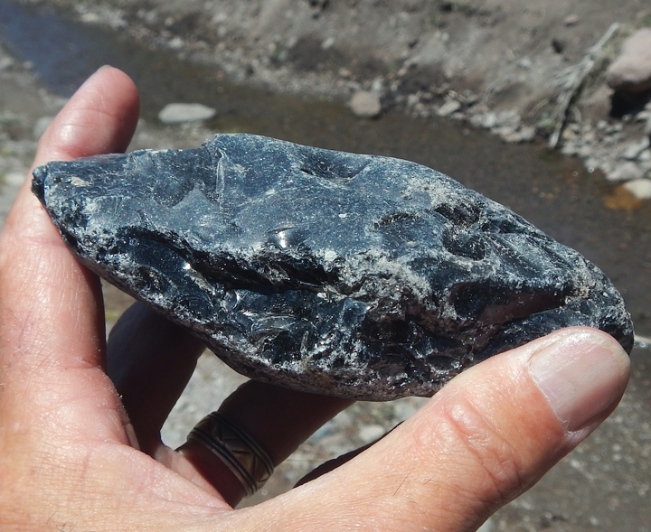
Cerro del Medio (Fig. 1), the first Valles ring-fracture lava dome, is a famous archeological site for acquisition of obsidian (Fig. 6). Ancestral Puebloans mined this lava extensively for high-quality, crystal-free natural glass to make tools. Formation of compositionally pure glass requires that the lava erupted at a temperature above which crystals can form in the magma, about 900 °C (1652 °F). During and immediately after eruption, the viscous lava chilled (“froze”) quickly, avoiding growth of all but the tiniest black crystals of iron oxides, which make obsidian appear black. Native American tribes traded valuable “Valles” obsidian throughout the Southwest United States (Shackley, 2005).
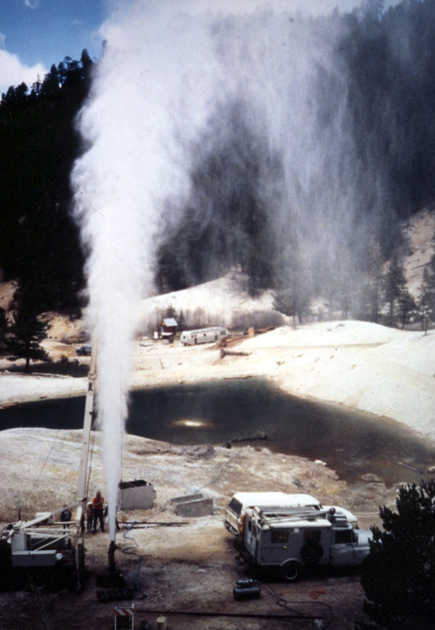
The immense quantity of heat released from crystallizing magma beneath the Valles (nominally 900 °C or 1652 °F) creates relatively shallow underground reservoirs of hot water; some of these waters reach the surface as hot springs and fumaroles (Fig. 7). Crystallizing magma also releases steam and acidic gases such as hydrochloric acid, hydrogen fluoride, carbon dioxide, hydrogen sulfide, and sulfur dioxide. These acidic fluids react with rock, forming a variety of secondary minerals such as clays, iron oxides, sulfur, sulfates, pyrite, and other minerals.
Ancient calderas, such as those in southern Colorado, are well-known hosts for gold-silver-copper-lead-zinc-molybdenum ores. Mining of ores in these eroded calderas resulted in many “boom towns” (i.e., Creede, Silverton, Platoro, etc.) and fabulous wealth for very few. Geothermal wells drilled into the Valles Caldera from 1962 to 1988 intersected superheated waters (about 300 °C or 572 °F) and small intervals of such ore minerals, but because subsurface temperatures are still hot, it is impossible to economically mine these intervals. Valles Caldera became a National Park (Valles Caldera National Preserve) in 2016, so mining and geothermal exploration activities are now prohibited.
Further Reading
Goff, F., 2009, Valles caldera – A Geologic History: University of New Mexico Press, Albuquerque, 114 p.
Goff, F., 2010, The Valles caldera – New Mexico’s supervolcano: New Mexico Earth Matters, Winter 2010, p. 1-4.
Goff, F., and Goff, C.J., 2017, Overview of the Valles Caldera (Baca) geothermal system, in (McLemore, V.T., et al., eds.), Energy and Mineral Resources of New Mexico: New Mexico Bureau of Geology and Mineral Resources, Memoir 50F, 65 p.
Goff, F., Gardner, J.N., Reneau, S.L., Kelley, S.A., Kempter, K.A., Lawrence, J.R., 2011, Geologic map of the Valles caldera, Jemez Mountains, New Mexico: New Mexico Bureau of Geology and Mineral Resources, Geologic Map 79, 1:50,000 scale, color, w/30 p. booklet.
Shackley, M.S., 2005, Obsidian: University of Arizona Press, Tucson, 246 p.
Smith, R.L., and R.A. Bailey, 1968, Resurgent cauldrons: Geological Society of America, Memoir 116, p. 613-662.
Smith, R.L., Bailey, R.A., Ross, C.S., 1970, Geologic map of the Jemez Mountains, New Mexico: U.S. Geological Survey, Miscellaneous Investigations Map I-571, 1:125,000 scale, color.
Westgate, J.A., WoldeGabriel, G., Halls, H.C., Bray, C.J., Barendregt, R.W., Pearce, N.J.G., Sarna-Wojcicki, A.M., Gorton, M.P., Kelley, R.E., and Schultz-Fellenz, E., 2018, Quaternary tephra from the Valles caldera in the volcanic field of the Jemez Mountains identified in western Canada: Quaternary Research, 1-16.
I found this very informative and interesting. Thank you.
Fraser and Cathy, thanks for this highly readable summary. The ash distribution graphic is new to us and really helps. I really appreciated the photos and the descriptions on them.
You two have made our surrounding landscape more understandable for us non-geologist scientists.
Thanks for the excellent summary. We highly recommend your Preserve van tour to friends and to all. While cross-country skiing the trails at the Redondo Campground, near the SW boundary of the Preserve, we were told that some of the deep (50-100′), near-circular, depressions are volcanic craters. Can you comment?