Length: 1.5 miles roundtrip
Elevation Gain: 200 feet
Difficulty: Easy
Suitable For: Hiking, running, good for families. Mountain biking is permitted but the short canyon ending in a dead end makes it somewhat unappealing to riders.
By Craig Martin
A short, shady trip up the Neblina’s Trail offers a quiet getaway close to town. The trail traverses under tall pines and is a cool trip even on a summer afternoon. The area was relatively untouched by the Cerro Grande fire, although the stream channel is choked with debris from floods following that fire and the Las Conchas fire. Tall, orange cliffs flank the canyon, and the trip ends in a narrows where cliffbush thrives in a thick stand.

The origin of the trail’s name is rather foggy, and it is likely applied to the wrong trail — for which I am to blame. Neblina is Spanish for mist, but I can find no written record of how the trail received that name. Perhaps it was someone’s name, hence the name usually has an apostrophe s. Neblina’s Trail can be found in Dorothy Hoard’s Los Alamos Outdoors, applied to a trail climbing through an unnamed canyon just to the west of Cabra Canyon. That trail was also considered part of the Cabra Loop Trail, and the name Neblina’s Trail was rarely used. In the aftermath of floods following the Cerro Grande fire in 2000, we moved the western entrance to the Cabra Loop Trail out of the unnamed canyon. But when I stumbled along the social trail heading up the next canyon to the west, I mistakenly thought it was Dorothy’s Neblina’s Trail. When the Santa Fe National Forest permitted a Youth Conservation Corps crew to upgrade the trail, my use of Neblina’s Trail stuck.
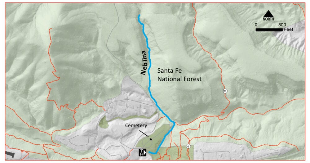
Finding the Trailhead: From the intersection of Diamond and Trinity, head north toward the high school and golf course on Diamond Drive. In 2 miles, turn left onto Range Road. In 0.3 miles, just past the entrance to Guaje Pines Cemetery park in the small parking area on the left.
The Trail: You’re not quite at the Neblina’s Trail yet. Head north on a rutted dirt road that parallels the cemetery fence along the edge of ponderosa pine woods. In a few minutes, drop into the Rendija Canyon drainage.
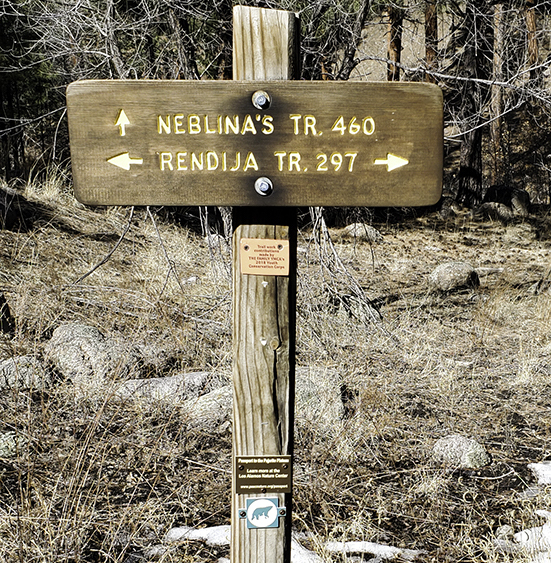
Just across the stream channel, turn right on an unmarked trail where the Perimeter Trail heads left. In a minute, you’ll see the sign at the start of the Neblina’s Trail.
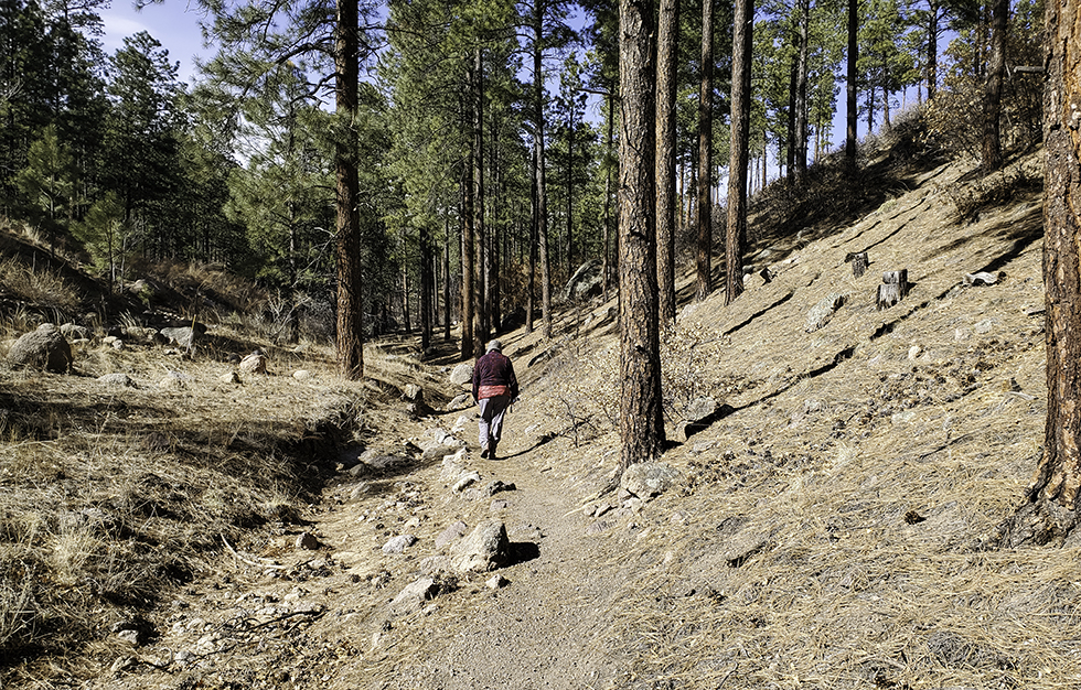
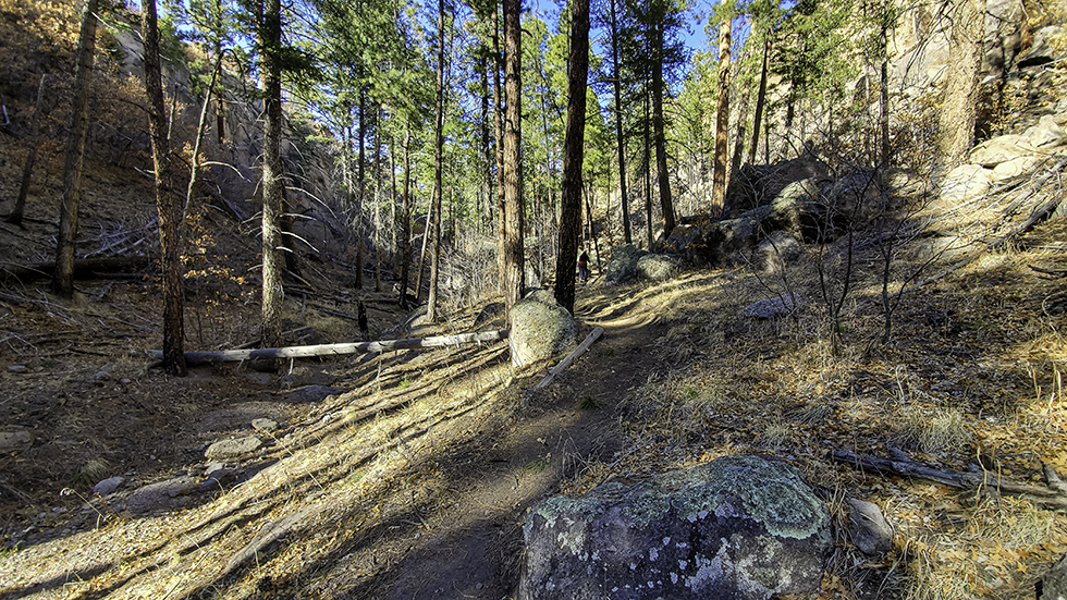
Cross the gravel in the stream channel and climb a low ramp to head up the canyon. The canyon here is wide, with coyote willows along the channel and sloping canyon sides reaching up to orange cliffs of Bandelier tuff. The trail skirts along the channel, traversing through ponderosa pine forest.
After a few minutes, the canyon abruptly narrows and the pines become denser. In summer, this section of the trail is always shady and cool.
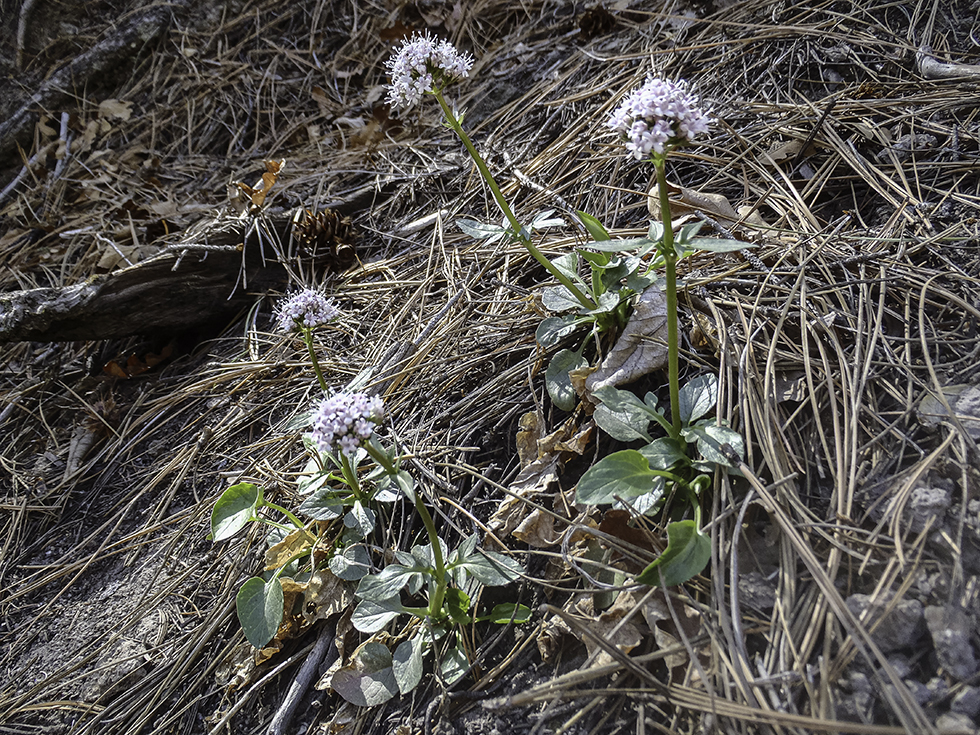
The trail winds between boulders as it heads up the canyon. In March, watch for the pinkish white balls of Arizona valerian bloom in the shadiest spots.
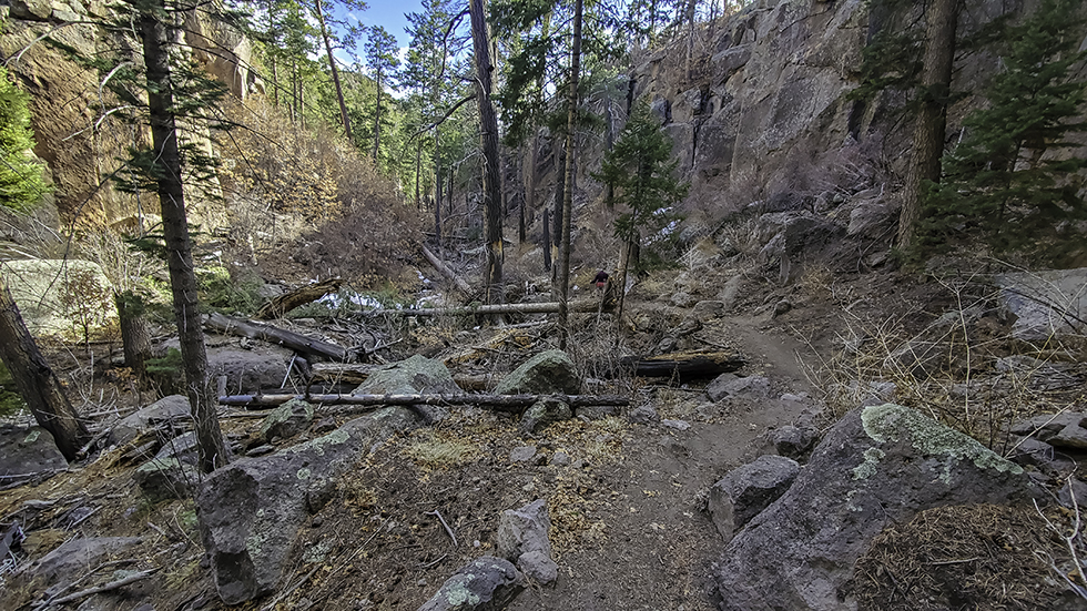
Cross and re-cross the stream channel, which is choked with boulders and logs brought down canyon by post-fire floods. About a half mile from the start of the trail, approach the canyon narrows on a long ramp constructed by the YCC.
You might want to turn around at the top of the ramp as the trail suddenly drops steeply back to the canyon floor. Then the trail ends about 100 feet upstream. Return to the parking area by the same route.
Extensions: It is possible, but difficult, to climb out of the canyon near the end of the trail. It is a short, steep scramble up the steep slope to the left to reach the Upper Guaje Canyon Trail, which is the old road heading north from the cemetery. Don’t try this if you don’t have good route-finding skills.
The Mystery of Neblina’s Trail, Added March 15, 2021:
One thing I’ve learned while writing about local history for the past 20 years is that if there’s a mystery behind some fact, there is someone who knows the answer. State the mystery in print and hope that it finds a way to that knowing person.
So it is with the origin of the name Neblina’s Trail. Shortly after my trail blog about the trail was published on the PEEC website, I received an email from White Rock resident Corry Clinton explaining how the trail got its name.
Corry rides horses and has ridden them locally for a long time. A few years back, she and other residents sponsored annual 50-mile endurance rides that took riders over the rough terrain north of Los Alamos to the summit of Caballo Mountain and back. Corry and the others would spend a couple of months doing trail maintenance to clear the trails before the endurance ride.
At the time, Corry had a horse named Neblina. “She was 7/8 Arab, 1/8 Morgan, and she was kind of a holy terror: fast, tireless, very forward, competitive, and of amazing stamina,” Corry said in her email. One weekend Neblina decided to take a slightly different route home, heading down the drainage just west of Cabra Canyon. Because no one knew of a name for that trail, they, and their trail-user friends, began calling it Neblina’s Trail.
Yes, today’s Neblina’s Trail is in the wrong place, but the name of the dark, spunky horse lives on. Thanks to Corry for sharing the story!
I first discovered Neblina’s Trail by happy accident. I had gone up the Cabra Trail not far down Rendija Canyon just past the Upper Rendija turnoff. I had come out on the old road (Upper Guaje Canyon Trail?) and followed it west then south. But that hike had exhausted both me and my dog. When we came to where the road swings west and climbs a couple of hundred feet up a ridge, I wondered whether it was possible to go left (east) around the end of the ridge, down the canyon. I went that way, and sure enough, someone had placed a few rock cairns along what seemed to be a traversable route. But the cairns only went 100 yds or so.
From there, it was scrambling over/under/through all the fallen logs from the fire. Some places it was better in the drainage, other places a little up the east side. Further south, the only route was to climb up over rock outcrops, first on one side, then on the other. My dog started lying down and waiting while I found a feasible route. It was getting dark, and we were exhausted and out of water when I finally, going over one of the outcrops, found the end of the Neblina’s Trail.
Never was I so happy to find a clear, easy trail!
I loved reading this: “Neblina’s Trail can be found in Dorothy Hoard’s Los Alamos Outdoors, applied to a trail climbing through an unnamed canyon just to the west of Cabra Canyon.” I’ve lived in Los Alamos since 1985 but still have a sense of mystery about the trails before and after the Cerro Grande fire. There were so many trees before the fire and they sometimes obscured connections. There are places and configurations of trails that I remember before Cerro Grande but can’t always pinpoint precisely where they were. I liked that you explained one mystery. Thank you for your blog on the trails!