NAME OF TRAIL: Kwage Mesa Utilities Road
LAND OWNER: Los Alamos County
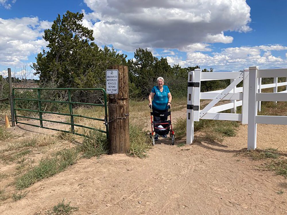
TRAIL CHARACTERISTICS AND ACCESSIBILITY: The utilities road is accessible to the Rollator Walker, but the traditional trailhead is inaccessible due to the rocks and narrowness of the trail. The traditional route for the Kwage Mesa Trail begins at the play-lot and North Mesa tennis courts off of North Mesa Park Road. This route is very rocky and narrow but does have signage. However, the utilities road is accessible because it is wide, not eroded, and very gently sloped.
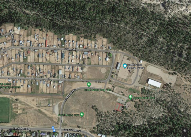
LOCATION: From Diamond Drive go straight across the roundabout to North Mesa Road. Follow the road until it curves (beyond the Posse Shack on the left and RV storage area on the right). Do not take the dirt road that is at the curve but continue on North Mesa Road to the entry into the Horse Stables. Slowly go down that road until you come to a gate. Go through the gate and you will see the Red Jackson Dressage Arena in front of you. To the north side (to the left) of the Arena you will note a closed green gate with an opening to the utilities road. There is parking at the play-lot and at the Arena. Park in the area and bring the mobility instruments to the gate area. The utilities road continues on the length of the mesa and is nearly flat.
OTHER ASSESSMENTS: Hiking, horseback riding, mountain biking, views, wildlife.
****
DATES OF ASSESSMENTS: June 27, 2021, August 21, 2021, September 19, 2021, and October 21, 2021.
TIME OF ASSESSMENT: 1:30 – 3:00 PM for all except the October hike, which was at 10:00 AM.
WEATHER CONDITIONS: The October hike was a sunny, calm, beautiful October day. Weather conditions for the other hikes were not recorded.
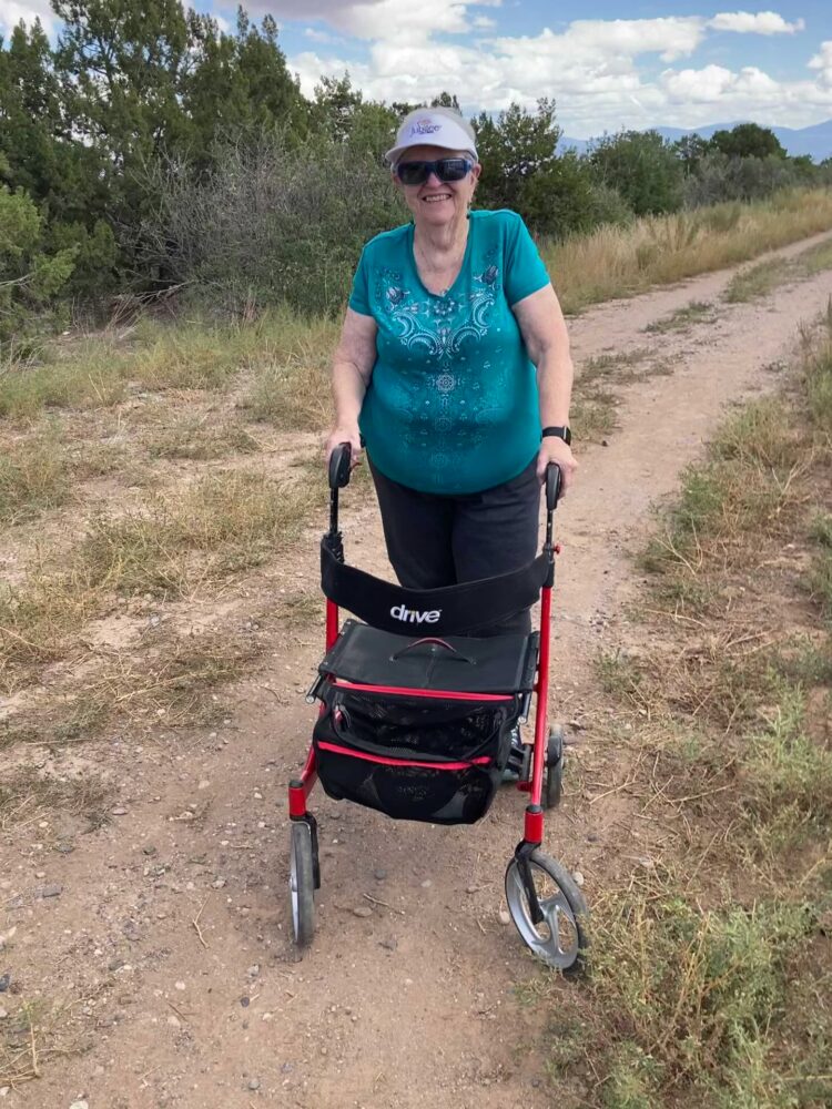
EVALUATORS: Teralene (Terry Foxx) and Charles “Jim” Foxx; The October hike consisted of 7 hikers, 4 using different Rollator Walkers.
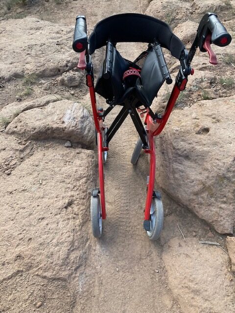
MOBILITY DEVICE USED (e.g. motorized or self-propelled wheelchair, rollator walker): Drive Medical RTL10266 Nitro Euro Style Rollator Walker, standard height, 10 inch wheels, 23 inches wide at the base.
OTHER EQUIPMENT: Tape Measure App (by Level Labs LLC), My Altitude App (by Dayana Networks, LTD), Steps-Activity Tracker (Pedometer and Steps, Year of Code LLC).
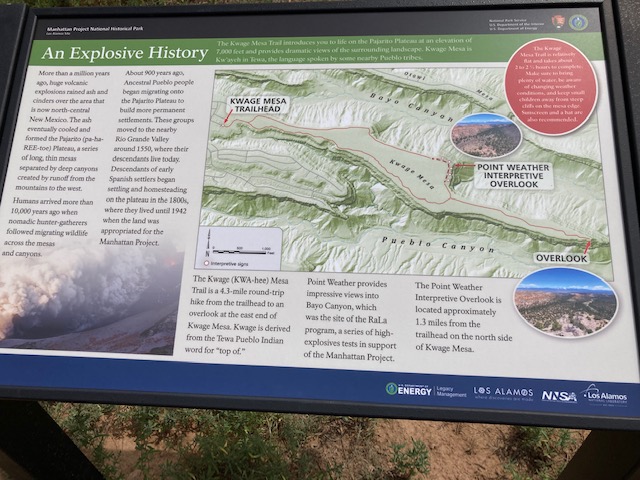
TRAIL SIGNAGE: There is no sign at the beginning of the utilities road. However, a sign has been installed at the play-lot that gives some history of the trail. This sign is at the beginning of the rocky and narrow traditional trailhead that is not accessible to the disabled. Supposedly there are other signs along the traditional trail, but we were unable to verify this.
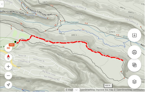
OVERALL TRAIL LENGTH: The overall length of the loop trail is 4 miles round trip.
ELEVATION: 7312 ft at the beginning of the trail. At the point where we stopped it was 7159 ft.
ELEVATION CHANGE: 600 ft total.
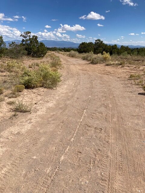
TRAIL WIDTH: The utilities road down the mesa is at least 10 ft wide, relatively smooth, and with little erosion. The beginning of the traditional trail is narrow and rocky and not accessible to Rollator Walkers.
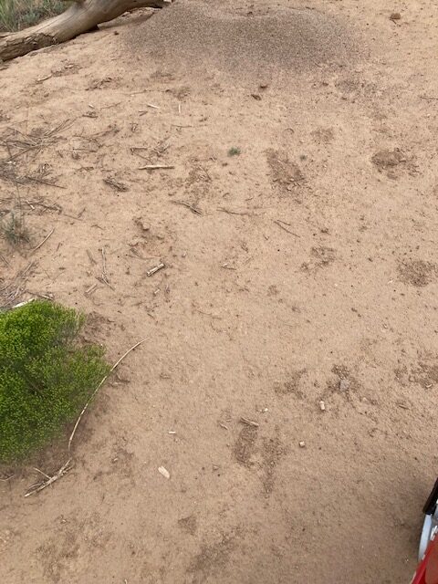
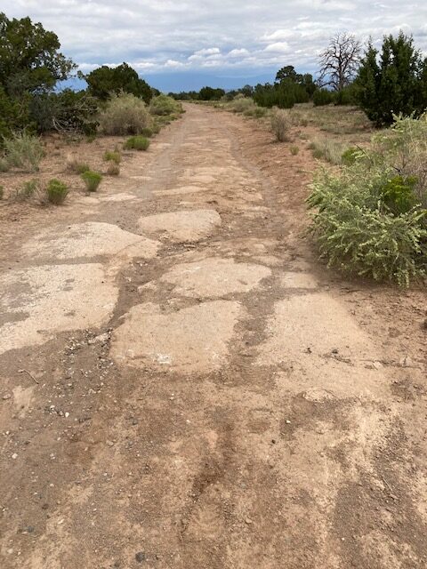
TRAIL SURFACE: Packed soil, sand, some rocks; the beginning of the utilities road has chipped gravel but the remainder is packed soil.
TRAIL SLOPE: Nearly flat once you reach the road. We measured the side by side slope as 1% and the beginning of the trail as 1.75%. (A trail is considered inaccessible with a side by side slope of 5%). This trail meets the accessibility criteria.
OBSTACLES/PROTRUDING OBJECTS: Once on the road there are very few obstacles. Most of the rocks that are present have been flattened by the road grading. There is some sand but most can be avoided by staying in the middle of the road.
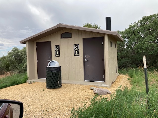
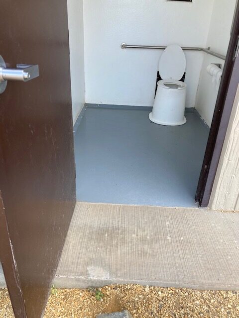
ACCESSIBLE RESTROOM FACILITIES: There is an ADA accessible restroom at the Red Jackson Dressage Arena. It appears to be wheelchair accessible except for the concrete pad on which the restroom sits. There is a lip of about 2-3 inches. This restroom is not in the immediate vicinity of the play-lot or the utilities road and requires some walking or riding to get to the area.
GATE WIDTH: The north side of the Red Jackson Dressage Arena has a gate that is ample width for horses and all the tested Rollator Walkers. Other gates are also wide enough for the Rollator Walker.
STEPS: None.
BENCHES OR OTHER RESTING PLACES: None.
SHADE: The trees do not shade the trail. It is very exposed.
RAILINGS: None.
TRAFFIC LEVEL: On some occasions we saw horse traffic and runners. From the play-lot we saw one family hiking the trail.
CONNECTING TRAILS: The Kwage Mesa Loop Trail, which includes both the north and south trails
ECOSYSTEM: Pinon/Juniper Woodland with a few scattered Ponderosa pine. An under story of scrub oak and other shrubs.
COMMENTS: In July, Jim and I walked the traditional route to Kwage Mesa. It was rocky and he had to help me get past the rocks. I immediately determined this trail as inaccessible to those with mobility issues. Someone commented to me that Kwage North Rim Trail would be a nice trail if you could get beyond the rocks. They said the road was easy. We decided to give the road a try. My husband helped me get beyond the rocks to the road and it was an easy walk with the Rollator Walker for over a mile (one way) and beyond. There were very few rocks and almost no erosion. The buried pipeline was noted about every .1-.2 mile.
My husband said this about the utility road, ”This is one of the best trails we have been on. Too bad there are so many rocks at the beginning.” Then we discovered the utilities road went around the north end of the Red Jackson Dressage Arena. The utilities road was nearly flat and made the trail accessible to horses, mountain bike riders, and those with mobility issues.
In October, the PEEC Nature Center and Los Alamos Senior Center sponsored a hike for those using mobility devices (October 21, 2021). We went with seven individuals, two of which had mobility issues. Two individuals represented the Nature Center and Senior Centers. We experimented with four different types of Rollator Walkers, did some perching exercises for resting, and walked approximately one mile (a mobility compromised person determined out and back distance). With the perching exercises we spent a few moments listening, smelling, and observing. The group commented that the chance to be quiet for a time was very rewarding. We spent some time looking at a few of the plants along the road. Jim Foxx pointed out Chicoma (also spelled as Tschicoma or Tchicoma), the highest peak in the Sierra de Los Valles, and told about his observations of when the snow left. Since many times when the snow left early on Chicoma it was often a fire year, the Foxxes had developed this folklore statement: When early the snow disappears from the high peak, beware, fire may be in the air.
It was a beautiful fall day and we were out in a part of nature that gave us a sense of being out of the hustle and bustle.
MAP:
REFERENCES
The following references have been used in these observations:
Harrington, Cindy, 2017, “What Exactly is an Accessible Trail?”, http://barrierfreetravels.com/2017/07/what-exactly-is-an-accessible-trail/. Accessed April 14, 2022.
“Access Considerations for Birding Locations, https://www.birdability.org/access-considerations. Accessed April 14, 2022.
Forest Service, U.S. Department of Agriculture, “Accessibility Resources”, https://fs.usda.gov/managing-land/national-forests-grasslands/accessaability/resources. Accessed April 14, 2022.
Laws, John Muir, “John Muir Laws, Nature Stewardship Through Science, Education and Art”, https://johnmuirlaws.com/deep-observation/. Accessed April 14, 2022.
Hoard, Dorothy, Los Alamos Outdoors, Los Alamos Historical Society, 1993.
Hoard, Dorothy, A Guide to Bandelier National Monument, Los Alamos Historical Society, 1989.
Rae, Coco, Hiking Trails in Valles Caldera National Preserve, University of New Mexico Press, 2020 .

Disclaimer
The vision of the Los Alamos Nature Center is that being in nature is for everybody: adults, children, able bodied individuals or people with disabilities. This blog is presented here so an individual can make decisions for themselves as to the appropriateness of an individual trail. The items reviewed are at the suggestion of the Birdability.org.