NAME OF TRAIL: Apache Springs Trail, Bandelier National Monument
LANDOWNER: Bandelier National Monument
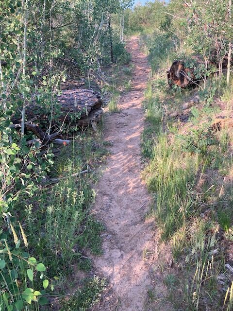
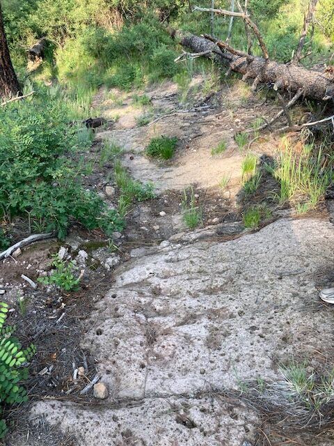
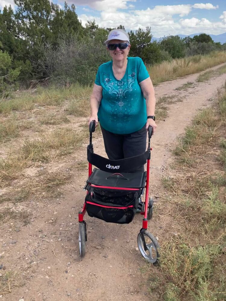
TRAIL CHARACTERISTICS AND ACCESSIBILITY: Inaccessible to Rollator Walker. The trail was less than 36 inches wide, in most places assessed. With the Rollator Walker the narrow trail was sometimes difficult to access. One wheel had to be on the dirt path and the other on the vegetation.This tilted the Rollator Walker slightly. However, when we reached the slope going to the meadow (about 1/4 mile) large rocks and the steep slope made it very difficult to go further and we stopped at that point. This was disappointing because, according to my hiking companion, Keegan, the trail was much better after that.
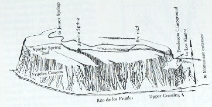
LOCATION: Access to the trailhead is off Fire Road 3, which branches off State Route 4, west from the Ponderosa Campground. The road is closed to private vehicles. The trailhead is on the south side of the road nearly opposite the American Springs Road. However the road is difficult to see because of the shrubs and trees. The entrance is obscured by shrubs but there is parking for 3-4 cars at the entrance to the trail.
OTHER ASSESSMENTS: Backpacking, camping, hiking, wildlife, historic spring.
***
DATE OF ASSESSMENT: July 13, 2021
TIME OF ASSESSMENT: 7:30 AM
WEATHER CONDITIONS: Sunny and warm.
EVALUATORS: Keegan Tranquillo and Terry Foxx
MOBILITY DEVICE USED (e.g. motorized or self-propelled wheelchair, rollator, rollator walker): Drive Medical RTL10266 Nitro Euro Style Rollator Walker, Standard Height, 10 inch wheels, 23 inches wide at the base.
OTHER EQUIPMENT: Tape Measure App (by Level Labs LLC), My Altitude App (by Dayana Networks, LTD), Steps-Activity Tracker (Pedometer and Steps, Year of Code LLC).
TRAIL SIGNAGE: There is a sign at the trail-head but with no distance information. Distance information is noted on a sign beyond this trail-head sign.
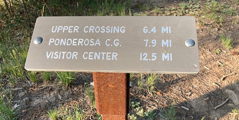
OVERALL TRAIL LENGTH: The total length of the trail to Ponderosa Campground is 8.6 miles. Much of the trail is within Frijoles Canyon. When the trail, within the canyon, meets the Upper Crossing Trail there is a choice to go to Ponderosa Campground or the Headquarters.
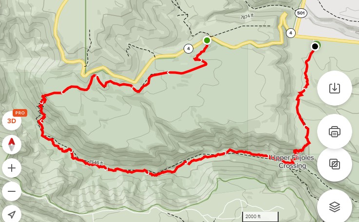
HOW MUCH OF THE TRAIL WAS EVALUATED?: A total of .19 miles or 1/4 mile was evaluated. Total round-trip for the evaluated area was .39 miles. The assessed area was before the top of the slope going into the meadow. The area south of the meadow is primarily aspen but the meadow area was inaccessible because of the rocky and eroded slope. This slope was very rocky and no attempt was made to continue walking with the Rollator Walker.
ELEVATION: The beginning elevation at Apache Springs is 8209 ft.
ELEVATION CHANGE: The elevation change is 1207 ft if you do the whole distance to Ponderosa Campground, due to accessing the depths of Frijoles Canyon. At Upper Crossing you can choose to hike on to the Visitor Center or Ponderosa Campgroup along the Upper Crossing trail. The Upper Crossing Trail from Ponderosa Campground was not accessible to the Rollator Walker due to rocks and root barriers
TRAIL WIDTH: The width in places was less that 2ft, in other areas, a two track logging road. Keegan indicated they are improving the trail from the rim.
TRAIL SURFACE: Packed soil.
TRAIL SLOPE: Nearly flat until the slope to the meadow, at which point I went no further as the slope was steep and very rocky. This was unfortunate because the road was much easier after that slope.
OBSTACLES/PROTRUDING OBJECTS: Small rocks, but also large and difficult rocks at the point where the trail goes down to the meadow.
ACCESSIBLE RESTROOM FACILITIES: None
GATE WIDTH: You can walk around the gate. The gate prevents motorized access.
STEPS: None.
BENCHES OR OTHER RESTING PLACES: None.
SHADE: Trees shade the portion of the road accessed.
RAILINGS: None.
TRAFFIC LEVEL: We saw no other persons during our assessment.
CONNECTING TRAILS: You can go all the way to Ponderosa Campground or take the remaining portion of the trail to the headquarters.
ECOSYSTEM: A secondary mixed conifer forest burned by the 1977 La Mesa Fire and the 2000 Cerro Grande Fire. Many Ponderosa pines showed scorching at the base. Some trees had fallen. Plots were set up along the upper road by Foxx in the La Mesa study and information can be found in summaries of that study. The area had been reseeded by Sheep Fescue (not native to the area) and it took over a large area. From my studies, I believe transplanting non-natives is not a good idea after fire. Erosion will happen before the plant matures.
Apache Spring is one of a number of small springs lying at the zone of contact between the dacite core of the Jemez Mountains and the overlying welded tuff. The spring once served cattle and sheep drives from the Espanola Valley to the summer pastures in the Valles Caldera.
In 1935-1937, a CCC project, the spring was encased in concrete. The Spring is located in a small canyon. (ref. Hoard, D. A Guide to Bandelier National Monument. 1989)
According to Keegan, this is also a bird banding site.
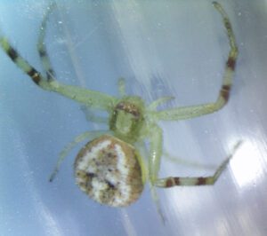
COMMENTS: Keegan continued on, but I perched on my Rollator Walker and enjoyed the breeze and sounds. I found a small spider the size of a pin-head on a plant that makes me wonder, and I’d like to find out all about him. He is a green crab spider! Sometimes he is called the flower foliage spider. His long legs move, like a crab, in all directions.
MAP:
REFERENCES
The following references have been used in these observations:
Harrington, Cindy, 2017, “What Exactly is an Accessible Trail?”, http://barrierfreetravels.com/2017/07/what-exactly-is-an-accessible-trail/. Accessed May 9, 2022.
“Access Considerations for Birding Locations, https://www.birdability.org/access-considerations. Accessed April 14, 2022.
Forest Service, U.S. Department of Agriculture, “Accessibility Resources”, https://fs.usda.gov/managing-land/national-forests-grasslands/accessaability/resources. Accessed April 14, 2022.
Laws, John Muir, “John Muir Laws, Nature Stewardship Through Science, Education and Art”, https://johnmuirlaws.com/deep-observation/. Accessed April 14, 2022.
Hoard, Dorothy, Los Alamos Outdoors, Los Alamos Historical Society, 1993.
Hoard, Dorothy, A Guide to Bandelier National Monument, Los Alamos Historical Society, 1989.
Rae, Coco, Hiking Trails in Valles Caldera National Preserve, University of New Mexico Press, 2020.
Disclaimer
The vision of the Los Alamos Nature Center is that being in nature is for everybody: adults, children, able bodied individuals or people with disabilities. This blog is presented here so an individual can make decisions for themselves as to the appropriateness of an individual trail. The items reviewed are at the suggestion of the Birdability.org.